Monitoring Network Protects International Aquaculture Investment
The driving force in the aquaculture industry worldwide is the growing demand for humans to have a healthy food source. Aquaculture is the term used for the cultivation, or “farming”, of aquatic species.
Located in southwestern South America, Chile is the world’s second largest salmon and trout producer. This is due in large part to the high quality of its Antarctic-fed Pacific Ocean waters. Chile exports over $1 billion in farm-raised salmon and trout per year. There is no native salmon in southern hemisphere.
Managing the effects of large-scale farming practices on the water resources is a long-term challenge not only for Chile, but also for the commercial companies working there.
INTESAL uses YSI environmental instruments and systems as a part of its extensive water monitoring and data collection network.
Salmon industry responds
INTESAL has five monitoring stations in the region around the city of Puerto Montt, capital of Chile’s X Region (Los Lagos), and Chiloe Island. There is also one system in Duncan Port in the southern XI Region.
“[This] project has enormous value for the region,” said Adolfo Alvial, manager of INTESAL to Simtech Ltda, YSI’s Chilean selling partner.
The stations continuously monitor various water and weather conditions. This data, and satellite imagery from NOAA, Envisat, and SeaStar, are combined into a comprehensive SEI (System of Environmental Information), which informs predictive models for climatic changes in surf, tides, and plankton proliferations, as well as possible diseases in salmon.
All of the environmental data is crucial to protecting the aquaculture investment. Remote monitoring of water quality and velocity at fresh water fisheries, lake sites, and marine centers allows INTESAL to create and control the best conditions for fish. It also provides early warning for potential threats, such as noxious algal blooms and low dissolved oxygen events, which can cause stress in the fish.
The systems also predict weather phenomenon, such as high winds and large tidal fluctuations, which might destroy equipment and structures, and aggregations of jellyfish and sea lions that can be harmful to fish cages.
The SEI is important not only for commercial interest, but also for the environment. Opponents of large-scale fish farming operations claim that nitrogen from fish waste is a contributing factor to harmful “red tides.” High levels of nitrogen aid the growth of algae, both toxic and nontoxic, and the proliferations of toxic algae create anoxic “dead zones” in the water. These are oxygenless areas where marine life cannot live.
One of the monitoring sites is in Pulelo, in the Chacao Channel between Puerto Montt and the Chiloe Island. Chacao is on the edge of a continental shelf and the swiftly moving Pacific drives strong currents into the channel along with stormy weather.
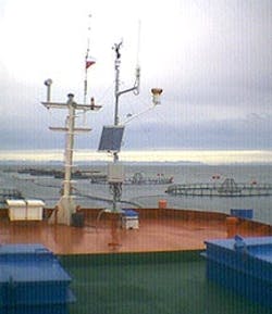
Salmon farming in Pulelo requires rugged equipment. This site uses two YSI multiparameter 600XLM sondes with sensors for water temperature, dissolved oxygen, and conductivity, and a SonTek/YSI Argonaut-XR acoustic Doppler current meter . The system also includes an Endeco/YSI 6200 data acquisition system with meteorological station , which measures wind speed and velocity, solar radiation, rain gauge, barometric pressure, and air temperature. The equipment is mounted on a feed pontoon near sea cages, and data is transmitted via radio frequency to a base station on land. The information is then relayed via Internet or cellular modem (GMS) directly to INTESAL facilities.
INTESAL’s five other monitoring sites are similarly equipped.
Long-term benefits
The total cost of this large-scale initiative exceeds $1 million. The project is funded by INTESAL, its participating commercial companies and the Fund for Development and Innovation (FDI) of Corfo.
Jose Miguel Troncoso, an INTESAL supervisor, summarizes the long-term goals of the monitoring project as follows:
- Quantify processes that define the ecosystem in which salmon are developed;
- Integrate data (plankton, benthos, oceanography, meteorology) in a local-scale model; and
- Extrapolate information, with support of satellite technology and water forecasting, to a meso (regional) scale.
Regional models and predictions for environmental changes are helping INTESAL’s partner companies define new farming options and transfer these practices to the industry. The methods are designed to protect fish health and increase production, while still using Chile’s water resources responsibly.
