Benefits of integrated sensor surveys in sewer systems
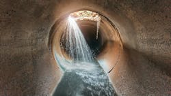
Integrated sensor surveys can be an effective way to determine the condition and performance of a wastewater collection system.
The U.S. EPA estimated that, in 2015, wastewater collection systems in the nation had a total replacement value of $1 to $2 trillion. Effective and continuous management, monitoring and maintenance is essential to ensure the continued service of collection system assets.
However, aging infrastructure and technological advancements are changing the dynamics of effective monitoring. Today, survey practices can employ sensor integration using CCTV, laser, sonar, GPS, gas and temperature sensing.
Integrated sensors can be a relatively small expense that provide substantial benefits. Inspection systems using these sensors can provide comprehensive assessments of trunk sewers during operation. These models serve as valuable references for maintenance, emergencies, design and future expansion.
How & where integrated sewer sensors help utilities
Integrated sensor surveys can provide information such as:
- Pipe location/track
- Pipe cross-section measurements (e.g., ovality)
- High resolution imaging
- Pipe restrictions, cross-section restrictions, erosion, encrustation, debris volume
- Pipe storage capacity values, water levels
- Any damage to pipes
- “As-Is” pipe sizes
A sewer survey case study
A small town of 12,000 people recently benefitted from an integrated sensor survey for its sewer system.
The town knew it had an issue with approximately 3 miles of trunk sewer. Basements were being flooded, so the municipality knew the pipe capacity was impacted. The town needed a condition assessment that included possible collapses as well as volume and position of solids in the sewer lines. The sewer line had not had a condition assessment in recent memory and there was no flushing program due to various difficulties.
In conjunction with a major engineering company, the town needed to put a bid package together for flushing and cleaning. After the initial budgetary numbers were calculated, the engineering company contacted AquaCoustic due to its experience with sonar surveys.
AquaCoustic used its four-wheel drive, steerable tractor and pontoon float for this project. For the pontoon float, a tow line was established between utility maintenance holes. Approximately 5,000 ft. of tow line and umbilical cable was available. The float was towed through the line collecting payout, CCTV and sonar data. Additional information such as pipe sags, and unmarked or buried utility maintenance holes were also noted.
The survey took 11 days to complete due to some of the difficult conditions, including buried utility maintenance holes, high water levels, high debris levels and some equipment issues.
Due to the detailed information provided post survey, the client received bids that were 40% lower than the initial budgetary figure. The cleaning project was also completed in a fraction of the initial timeline, thereby reducing traffic disruption and other cleaning impacts.
About the Author
Michael Blackshaw
Michael Blackshaw is the owner of AquaCoustic Remote Technologies Inc., a company that specializes in asset surveys.
Arthur Self
Arthur Self is a management professional operating Artana Solutions Inc.


