About the author: William Akin, P.E., is a project engineer for Pennoni. Akin can be reached at [email protected] or 856.656.2908.
As urban sprawl has extended its reaches farther away from city centers, the development of natural landscapes has caused issues with the healthy biodiversity of watersheds. This can be seen extensively in the fringe suburban developments that are nestled into headwater catchments. Small changes within their natural balances can cause a visible decline in water quality that can be easily monitored by watershed planners.
Putting this idea into perspective, headwater streams constitute approximately 75% of the total stream and river length in the U.S. while supplying 70% of the water volume to regional watersheds. These small streams can be used as strong indicators of water quality within a larger river basin. Impervious land coverage is increasing within these small catchments, causing increased volumes of storm water runoff that carry pollutants and a growing force of erosion that upsets the balance of hydrology and geomorphology within a tributary. Using the detrimental effects associated with runoff, it is possible to correlate a relationship between impervious cover and water quality.
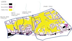
This case study focuses on four headwater catchments within the Valley Creek Watershed in southeastern Pennsylvania: Crabby Creek and the Vincent Road, North Valley Road and Hollow Road tributaries. These catchments were evaluated by taking an inventory of their impervious cover and physical characteristics.
Of the four streams, Crabby Creek is the only viable stream that supports a healthy biodiversity and is the control for the study. The remaining streams were compared to evaluate factors causing stream degradation. The results from this case study were used to help support existing theory on the impairment of streams with increasing impervious cover and poor storm water management planning.
Impervious Inventory
With the use of publicly available aerial photography, it was possible to take an inventory of the impervious surfaces within the four catchments. AutoCAD was used to map these areas and measure the overall coverage of impervious surfaces in comparison to each stream’s biodiversity assessment.
Due to time constraints for the study, driveways were estimated when they were not visible within the aerial photos. The estimated area was then added to each house to account for some portion of the impervious surface not visible.
Previous studies show that 12% impervious coverage is the threshold for negative effects within a watershed. All four headwaters have total impervious areas (TIA) above this percentage, alluding to the fact that all four should be impaired. However, to better assess these numbers, the effective impervious area (EIA) should be computed to see how storm water management plays a role in the hydrology of these streams.
Calculating EIA
The TIA was reduced to show EIA for both the U.S. Geological Survey (USGS) model and a more qualitative approach proposed by Roger Sutherland. The USGS model proposes a blanket reduction utilizing the following equation: EIA = 3.6 + 0.43(TIA).
This model works best for TIAs ranging from 10% to 50% but does not factor in types of storm water management. The Sutherland model, however, considers the type of connection storm water infrastructure has on the TIA. Crabby Creek’s investigation found curb and gutter present but little storm water management, resulting in the use of the average equation: EIA = 0.1(TIA)1.5.
The remaining headwater catchments had extensive storm sewer, curb and gutter, and roof drains connected directly to the street. For these catchments, the highly connected equation was used to find effective impervious area: EIA = 0.4(TIA)1.2.
The effective area calculations for the four watersheds bring the high impervious percentages down closer to the 12% threshold. Only Crabby Creek dips below the threshold, while the three remaining streams remain above the theoretical limit. Impervious coverage and poor storm water management practices tie directly into the water quality issues. This is even more evident using the Sutherland model, which considers the storm water management within each catchment and further divides the percentages within the healthy and impaired streams.
The overall forested cover for the catchments is another issue to take notice of within the data set. Forested areas have higher rates of evapotranspiration compared with grass, allowing less infiltration to feed the groundwater table that the streams depend on. The impervious coverage within the unforested areas is significantly higher in the impaired streams. A conjecture could be made that the three impaired streams have lower infiltration rates since there is less available pervious area for infiltration. This would lead to less water reaching the streams and further reducing water quality within each habitat.
Dissecting Data
The data taken from this study aligns itself with the current theory that 12% impervious coverage begins the degradation process for a headwater. Developers and local stakeholders need to keep this in mind when building in these locations, and better management practices need to be put in place to help deter the erosive and polluting power that storm water runoff entails. Crabby Creek has an extensive forested buffer along its banks showing this land management practice can aid in the biodiversity of a headwater. It is necessary to plan now and become stewards of these streams before their water quality declines and biodiversity is lost.

